Minnesota data
http://whitebear.gac.edu/waconia/Weathe ... ?region=MN
Washington and Oregon data (Columbia River)
http://whitebear.gac.edu/waconia/Weathe ... ?region=CR
I’ve recently moved back to MN from a 13 year stay in eastern Washington. Windsurfers, from the Tri-Cities area in WA, often sail at Roosevelt on the Columbia River near the east end of the Gorge. The links above are to a database/charting application that I developed originally for Roosevelt sailors but named, Waconia, after my favorite sailing spot in Minnesota.
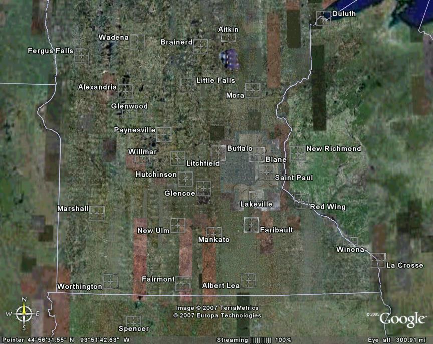
This summer I updated the application to include data collection from MN airport weather stations. You can see the MN sites I’m collecting from here:
http://whitebear.gac.edu/waconia/Weather/mn_sites.jpg
I picked airports in support of the lakes mentioned on LAKAWA. If you can think of other airport stations that would be useful to collect from let me know. I can get data from any station in this list:
http://adds.aviationweather.gov/metars/stations.txt
Take a look at the wind chart for Duluth on Thursday 8/10. I was at Park Point body surfing with my wife and sons. What a day!
The Weather Underground also has a database/charting application. But I’m hoping you’ll like Waconia better… Waconia is ad free, easy to use, and developed by a windsurfer for windsurfers.
http://whitebear.gac.edu/waconia/
Jim
Ok, there’s one catch. I’m asking that users consider sending their kids (the more the better) to study Physics at Gustavus Adolphus College in St. Peter. A small price to pay for good wind charts.
Physics, Waconia, and wind charts...
Moderator: MK
-
Jim Miller
- Posts: 16
- Joined: Sun Aug 06, 2006 9:47 pm
- Location: Saint Peter, MN
- Contact:
Physics, Waconia, and wind charts...
Last edited by Jim Miller on Thu May 17, 2007 11:25 pm, edited 2 times in total.
Thanks Jim.
Many times I have wondered what the wind was doing when I was out there and your graphs give a nice visualization of the conditions.
One comment. Would it be possible to plot an axis on the right with the wind direction on it? That way it would be easier (at least for me) to follow the wind direction instead of making the translation in my head. Pure laziness from me, hehe.
Denis
(================P-</
Sponsored by Slingshot Kiteboarding
Sponsored by Slingshot Kiteboarding
-
Jim Miller
- Posts: 16
- Joined: Sun Aug 06, 2006 9:47 pm
- Location: Saint Peter, MN
- Contact:
Wind direction
Denis,
The short answer is no because of limitations in the free tools that I use. But there is a compromise.
Try the "Wind (0-36)" option and check out the Help topic on this:
"Why are there two wind options, Wind (0-36) and Wind (0-40)?"
http://whitebear.gac.edu/waconia/Weather/FAQ.htm#4
Jim
The short answer is no because of limitations in the free tools that I use. But there is a compromise.
Try the "Wind (0-36)" option and check out the Help topic on this:
"Why are there two wind options, Wind (0-36) and Wind (0-40)?"
http://whitebear.gac.edu/waconia/Weather/FAQ.htm#4
Jim
Last edited by Jim Miller on Sun Jul 22, 2007 6:14 pm, edited 2 times in total.
-
Jim Miller
- Posts: 16
- Joined: Sun Aug 06, 2006 9:47 pm
- Location: Saint Peter, MN
- Contact:
W
Tighe-- Yes, please do add a link on the Wind page. It should work fine inside the frameset. Thanks for asking. --Jim
Wow, this is a great application for plotting past weather data. The other day I was just wondering where to get historical data so I could see what the actual windspeeds were when I was kiting...
I also think it would be interesting to superimpose forecasted data onto the actual data to visualize how well (or bad) they correlate. Just an idea...
Thanks for sharing!
I also think it would be interesting to superimpose forecasted data onto the actual data to visualize how well (or bad) they correlate. Just an idea...
Thanks for sharing!
-
Jim Miller
- Posts: 16
- Joined: Sun Aug 06, 2006 9:47 pm
- Location: Saint Peter, MN
- Contact:
Physics, Waconia, and wind charts. An update...
Hi everyone,
There are a few new features at Waconia:
http://whitebear.gac.edu/waconia/
The URL is now parameterized. This allows you to e-mail a link to a particular day/location or to save a shortcut that will give you the latest data at a particular location.
For example, here is a link created by copying the URL (as generated by charting yesterday’s at Mankato). I was sailing at my favorite local site (near Saint Peter), German Lake. This Mankato link gives you a good idea of the wind I had. Great day. By the way, I put in from the public access on the north side of the lake. Bring a weed fin when the winds are from the west (like yesterday). I would welcome a sailing buddy down here:
http://whitebear.gac.edu/waconia/Weathe ... Sat&Days=1
To create a URL that gives the latest data, just trim back the URL up to the sensor parameter. For example, here is the latest wind data for the Faribault airport:
http://whitebear.gac.edu/waconia/Weathe ... sor=Wind40
There is now a timer (click the "show timer" link). You can set Waconia to auto-refresh every 5 minutes. The Whitebear server time is also reported on the chart page (near the home link). So you can control the timer to get in sync with the fetching process on Whitebear (every 5 minutes, e.g. 1:25, 1:30, 1:35.). That way you get the latest data.
And check out the link in the words "Columbia Basin Weather" (or "Minnesota Weather") that takes you to the Minnesota (or Washington) sites. Use the same link to return.
The "sites" link on the Minnesota side shows an image of the MN airports that I collect data from. I’ve added a few new airports to my gleaning process (Faribault, New Ulm, Paynesville, and Albert Lea). Faribault should be handy for those folks that sail at Cannon Lake.
http://whitebear.gac.edu/waconia/Weather/mn_sites.jpg
And finally you may have noticed the new secondary-y axis, for direction, when charting wind. Thank you Denis for the reply (in this post thread) that helped motivate this improvement. I would have done it years ago if it was easy; it took one last good nudge to get me to figure out a way. The details are in the FAQ below on the two wind options.
http://whitebear.gac.edu/waconia/Weather/FAQ.htm#4
-
Jim Miller
- Posts: 16
- Joined: Sun Aug 06, 2006 9:47 pm
- Location: Saint Peter, MN
- Contact:
Re: Physics, Waconia, and wind charts...
I've retired from Gustavus and so ends the serving of the weather data from the links above. For those of you that are handy on the computer, you might consider installing this. Here's the how-to write-up:
http://waconia.triquence.org/Install_rosy.htm
Jim
http://waconia.triquence.org/Install_rosy.htm
Jim
Last edited by Jim Miller on Sat Feb 03, 2024 3:51 pm, edited 1 time in total.
-
Jim Miller
- Posts: 16
- Joined: Sun Aug 06, 2006 9:47 pm
- Location: Saint Peter, MN
- Contact:
Re: Physics, Waconia, and wind charts...
I've made a new public client for the weather histories:
https://waconia.triquence.org/weather.h ... 2&days=24h
Here is an updated description of the data sources:
https://waconia.triquence.org/FAQ.htm?DataSources
And the old picture is still a good summary of the MN sites:
https://waconia.triquence.org/pictures/mn_sites.jpg
Happy Easter to you all.
Jim
https://waconia.triquence.org/weather.h ... 2&days=24h
Here is an updated description of the data sources:
https://waconia.triquence.org/FAQ.htm?DataSources
And the old picture is still a good summary of the MN sites:
https://waconia.triquence.org/pictures/mn_sites.jpg
Happy Easter to you all.
Jim