Hey all,
I have been lucky enough to have been kiting for the last 2+ years, a time in which I have had a lot of water up my nose and many sore muscles to mend...but with every improvement in my riding skill, every jump to a new elevation and every new weather/wind condition experienced, my enthusiasm for the sport grows and GROWS!!! I would like to say thanks to this kiting community for your lessons and encouragement throughout this learning period.
One unanticipated thing I have learned about this sport over the last 2 years is that I need to be a better meteorologist but I am not sure of the best way to accomplish this task. Therefore, I am calling once again on the knowledge of this kiting community. I have called out Tighe, Stroh and Kevin O. because of the knowledge they obviously have as I read their posts but I welcome suggestions from any kiter.
I would like to be able to make decisions about where conditions will be best without relying solely on the weather sites. I am not sure if there is a good weather book to read or if it is just the product of experience that tells you which lake will be blowing best for that day. Any suggestions are welcome and thanks again for all the help!!!
Chad
Tapping the Weather Knowledge of Tighe, Stroh and Kevin O.
Moderator: MK
Re: Tapping the Weather Knowledge of Tighe, Stroh and Kevin
http://ready.arl.noaa.gov/READY_animations.php
I use the NAM and GFS for mid to long range forecasts, the day before and of, I use RUC (noaa exptl.)
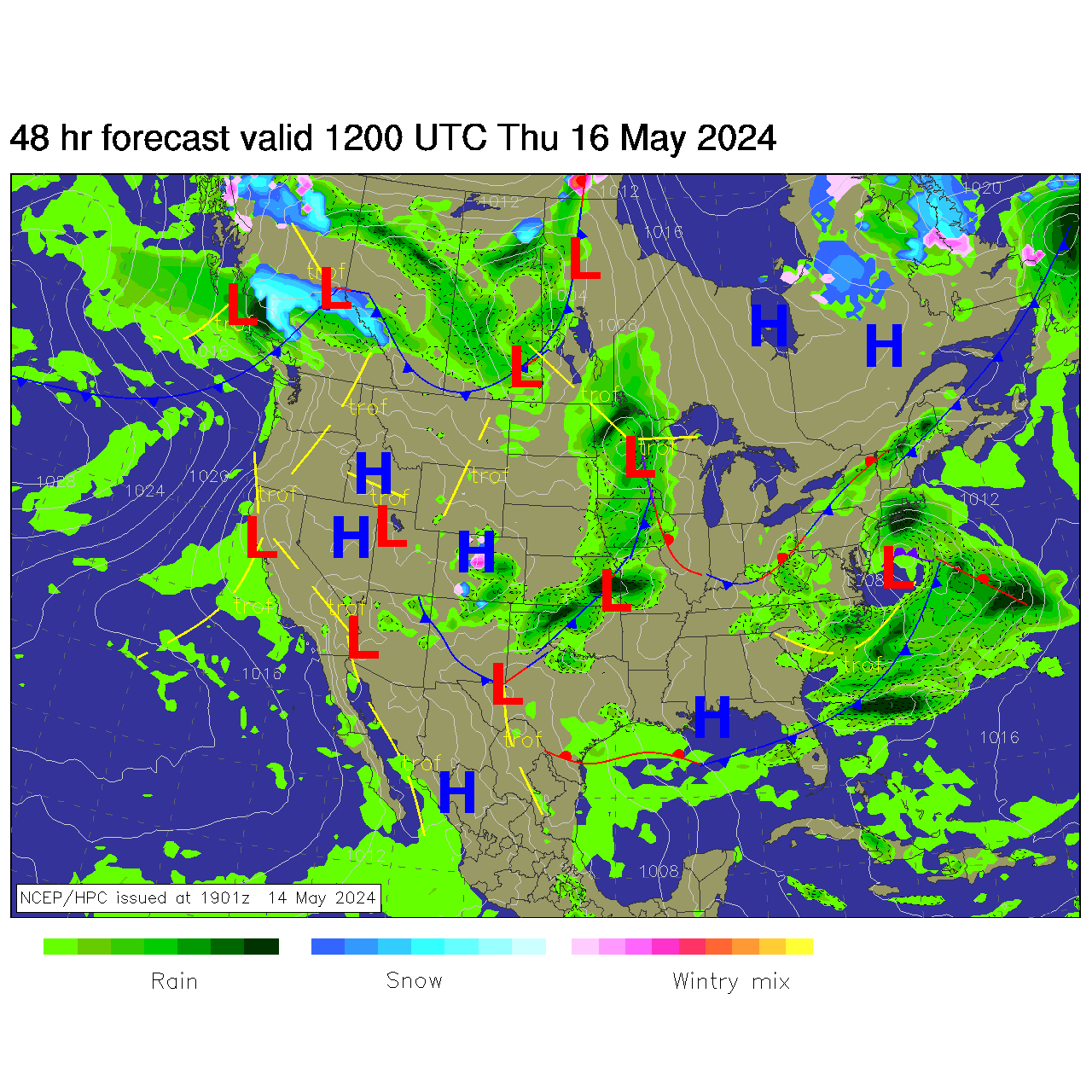
Wind blows clockwise and out from a high and counterclockwise and into a low. Take a look at tomorrow on the NAM we will be getting south winds as the low approaches and NW after it passes. The more stacked the Isobars (lines of equal pressure) are and the closer they are the stronger the wind will be.
If I am feeling lazy I put my trust in NWS!
RUC/noaa exptl.
http://ruc.noaa.gov/disp2.cgi?/w3/rapb/ ... rf_wind+gl
I use the NAM and GFS for mid to long range forecasts, the day before and of, I use RUC (noaa exptl.)
Wind blows clockwise and out from a high and counterclockwise and into a low. Take a look at tomorrow on the NAM we will be getting south winds as the low approaches and NW after it passes. The more stacked the Isobars (lines of equal pressure) are and the closer they are the stronger the wind will be.
If I am feeling lazy I put my trust in NWS!
RUC/noaa exptl.
http://ruc.noaa.gov/disp2.cgi?/w3/rapb/ ... rf_wind+gl
Jon Stroh
Re: Tapping the Weather Knowledge of Tighe, Stroh and Kevin
Jon - I checked out the NOAA RUC link you provided. I don't understand the labeling system provided for each forecast. For example:
2-hr fcst valid 02-Aug-11 08:00Z
Is this a forecast for wind that can be expected for 2 hours starting at 08:00? For 2 hours until 08:00?
Can't appreciate the significance of the forecast maps without an understanding of the labels. Would appreciate any clarification you can provide. Thnx.
2-hr fcst valid 02-Aug-11 08:00Z
Is this a forecast for wind that can be expected for 2 hours starting at 08:00? For 2 hours until 08:00?
Can't appreciate the significance of the forecast maps without an understanding of the labels. Would appreciate any clarification you can provide. Thnx.
Re: Tapping the Weather Knowledge of Tighe, Stroh and Kevin
They are using the 24 hour time format and the “Z” is for Zulu or Greenwich Mean Time. We are -6 hours from that during DST so 08:00Z would be 2:00am for us. The little symbols are called wind barbs and they show what direction the wind is coming from. The following link will take you to an explanation of how to read them. Scroll down to the wind speed and direction section for the description. http://www.srh.noaa.gov/jetstream/synop ... s.htm#ddff . These same wind barbs are used in the charts you see when you click on the Wind link at the top of the LAKAWA page. I hope this helps.
-
Kevinousdigian
- Posts: 646
- Joined: Thu Nov 28, 2002 10:37 pm
Re: Tapping the Weather Knowledge of Tighe, Stroh and Kevin
If I could only have one link to look at the 10 day MRF would be it as this is by far the most accurate tool for predicting winds.
http://weather.unisys.com/gfsx/gfsx.php ... on=us&t=9p
The initial view of the 10 day MRF show the model for each day at 7pm. You can get see the 7am model by clicking on the half days at the top.
The two key aspects to look for are:
1) Tight isobars: these are the obviously windy days.
Isobars are lines of equal pressure and so the tighter they are the more pressure difference there is and the more wind. I'd say a good cold front with tight isobars 7 days out is accurate over 75% of the time.
2) Dramatic color changes in 12-24 hours (eg the darker orange color followed by yellow)
Todays 10 day mrf is a great example. My forecast is that Sunday morning will be windy (15-20+) in northern WI.
Day 4:at 00Zulu Sunday (which is 7pm Sat night) shows a circle over North Dakota and it's orange over MN and WI
Day 5:Sunday at 7pm shows yellow over northern MN and a lot of yellow over WI. I believe that circle is a cool front that will sweep across the northern part of the state and especially northern WI.
Now drill in and look at day 4.5 which is Sunday morning at 7am:
http://weather.unisys.com/gfsx/gfsx.php ... on=us&t=4e
Check out the nice tight isobars and see that low pressure (now labeled L - it was the circle). That front is really moving fast though as by Sunday night it's way off east so don't sleep in.
Wind direction: the wind is always 45 east of the isobars. I'll be in NW WI at the cabin. The Low is to the east of there and the winds go counterclockwise around low so the wind direction of isobars is from 360 to 0 (note 360 means straight north, 180 is straight south). subtract 45 degrees from 360 and you get 315 which is NW. The further north you go the more the isobars bend to the NNE so the actual wind will be more NNW further N that morning.
Now NOAA isn't predicting any of this wind in fact they show 5 mph in Hayward WI on Sunday. Based on my observations over the year I have no idea what they look at but there are so many times that the 10 day mrf has showed strong winds a week in advance and NOAA doesn't get it right until the day of after it's been blowing 15-25, then they up their forecast. Hopefully they'll be wrong again so I can get some rides on Sunday morning.
Kevin
10 Day MRF
4 Day (7pm Sat 8/6) (See circle over ND and orange WI (temp around 80 degrees for most of state))
4.5 Day (7am Sun 8/7) (see how fast that front moved in 12 hours, was in ND now centered over N part of lake MI, now see tight isobars behind front (to the west of it) and also see cooler air (yellow instead of orange over N WI)
5 Day (7pm Sun 8/7) (front moved way east and will take good wind with it)
Hayward Forecast from NOAA Hourly Graph
http://weather.unisys.com/gfsx/gfsx.php ... on=us&t=9p
The initial view of the 10 day MRF show the model for each day at 7pm. You can get see the 7am model by clicking on the half days at the top.
The two key aspects to look for are:
1) Tight isobars: these are the obviously windy days.
Isobars are lines of equal pressure and so the tighter they are the more pressure difference there is and the more wind. I'd say a good cold front with tight isobars 7 days out is accurate over 75% of the time.
2) Dramatic color changes in 12-24 hours (eg the darker orange color followed by yellow)
Todays 10 day mrf is a great example. My forecast is that Sunday morning will be windy (15-20+) in northern WI.
Day 4:at 00Zulu Sunday (which is 7pm Sat night) shows a circle over North Dakota and it's orange over MN and WI
Day 5:Sunday at 7pm shows yellow over northern MN and a lot of yellow over WI. I believe that circle is a cool front that will sweep across the northern part of the state and especially northern WI.
Now drill in and look at day 4.5 which is Sunday morning at 7am:
http://weather.unisys.com/gfsx/gfsx.php ... on=us&t=4e
Check out the nice tight isobars and see that low pressure (now labeled L - it was the circle). That front is really moving fast though as by Sunday night it's way off east so don't sleep in.
Wind direction: the wind is always 45 east of the isobars. I'll be in NW WI at the cabin. The Low is to the east of there and the winds go counterclockwise around low so the wind direction of isobars is from 360 to 0 (note 360 means straight north, 180 is straight south). subtract 45 degrees from 360 and you get 315 which is NW. The further north you go the more the isobars bend to the NNE so the actual wind will be more NNW further N that morning.
Now NOAA isn't predicting any of this wind in fact they show 5 mph in Hayward WI on Sunday. Based on my observations over the year I have no idea what they look at but there are so many times that the 10 day mrf has showed strong winds a week in advance and NOAA doesn't get it right until the day of after it's been blowing 15-25, then they up their forecast. Hopefully they'll be wrong again so I can get some rides on Sunday morning.
Kevin
10 Day MRF
4 Day (7pm Sat 8/6) (See circle over ND and orange WI (temp around 80 degrees for most of state))
- gfsx_500p_4d.gif (27.5 KiB) Viewed 10235 times
- gfsx_500p_4e5.gif (27.36 KiB) Viewed 10235 times
- gfsx_500p_5d.gif (27.34 KiB) Viewed 10235 times
Hayward Forecast from NOAA Hourly Graph
- Hayward.png (26.17 KiB) Viewed 10235 times
Kevin Ousdigian
-
Kevinousdigian
- Posts: 646
- Joined: Thu Nov 28, 2002 10:37 pm
Re: Tapping the Weather Knowledge of Tighe, Stroh and Kevin
Good news - 10 day mrf still showing that front sweeping across only it slowed a little bit so could be breezy at Mille Lacs too on Sunday as well as Northern WI. It's not uncommon for the 10 day mrf to show some shifts from one day to the next and I often notice it shifts one day and the next day shifts back. NOAA is still showing < 10 mph wind for Aitkin and Northern WI but I'd say >80% likelihood of good wind in N WI and if the front is slow enough wind in N MN too.
Also yesterday and today the 10 day MRF has been showing the coldest air in 2-3 months coming here on Wednesday so it looks like it could be great NW winds up at ML. Again this front may be coming through later Tuesday too but it's coming...
Sunday 7am : see strong low almost centered over Duluth with tight vertical isobars in N MN along with big color change from day before. I'd say 15-25+ mph NW winds around ML and at the border of MN canada isobar so more NE to SW so wind will be more straight N (NE = 45 degrees then subtract 45 to get 0 = N)
Sunday 7pm front moved to lake MI so best winds are now in N WI
Wed 7am: yuk green is more like 60s so will be a chilly but windy morning. Note isobars are more vertical in N part of state so wind will be NW and in southern part they are more NW to SE so NW = 315 - 45 degrees = 270 = West wind in southern MN and in twin cities looks WNW early.
My guess as to why NOAA is not predicting wind is because they are using this model which doesn't show a strong front or isobars on Sunday. You can only predict as good as your model. We'll see which one is right for Sunday but based on what I've seen over the last 3-5 yrs the 10 day MRF beats them all. Yes it's wrong some too but it's easily right more often than all the others. Learning to read it helps with work and family planning so we can enjoy our wind passion since we don't live in an area that blows everyday.
NOAA Model for 7am Sunday
Bottom graph is NOAA aitkin forecast for sunday morning.
Also yesterday and today the 10 day MRF has been showing the coldest air in 2-3 months coming here on Wednesday so it looks like it could be great NW winds up at ML. Again this front may be coming through later Tuesday too but it's coming...
Sunday 7am : see strong low almost centered over Duluth with tight vertical isobars in N MN along with big color change from day before. I'd say 15-25+ mph NW winds around ML and at the border of MN canada isobar so more NE to SW so wind will be more straight N (NE = 45 degrees then subtract 45 to get 0 = N)
- gfsx_500p_3e.gif (27.01 KiB) Viewed 10204 times
Sunday 7pm front moved to lake MI so best winds are now in N WI
- gfsx_500p_4d Sunday.gif (26.92 KiB) Viewed 10204 times
- gfsx_500p_6e Wed.gif (26.43 KiB) Viewed 10204 times
My guess as to why NOAA is not predicting wind is because they are using this model which doesn't show a strong front or isobars on Sunday. You can only predict as good as your model. We'll see which one is right for Sunday but based on what I've seen over the last 3-5 yrs the 10 day MRF beats them all. Yes it's wrong some too but it's easily right more often than all the others. Learning to read it helps with work and family planning so we can enjoy our wind passion since we don't live in an area that blows everyday.
NOAA Model for 7am Sunday
- 9khwbgfnl_conus.gif (27.61 KiB) Viewed 10204 times
- Attachments
-
- aitkin Sun.png (27.08 KiB) Viewed 10204 times
Kevin Ousdigian
Re: Tapping the Weather Knowledge of Tighe, Stroh and Kevin
This is really great! Thanks for taking the time to put this together (especially KO)!
Re: Tapping the Weather Knowledge of Tighe, Stroh and Kevin
I second that notion. This will be helpful. Thank you!smrsco wrote:This is really great! Thanks for taking the time to put this together (especially KO)!
Re: Tapping the Weather Knowledge of Tighe, Stroh and Kevin
sorry for staying out of the thread. Been busy. Don't think I have much to add to the information given, other than maybe...trust your gut over the computer. Enjoy the day that unfolds in front of you, no matter what the wind does.
ride on
ride on
Tighe
Re: Tapping the Weather Knowledge of Tighe, Stroh and Kevin
I just use this: http://itg1.meteor.wisc.edu/wxp_images/avn/index.html
If you study the same map for years a real swell data base will be created in your head.
If you study the same map for years a real swell data base will be created in your head.
-
Lee_Uptown
- Posts: 251
- Joined: Mon Jun 23, 2008 8:46 pm
Re: Tapping the Weather Knowledge of Tighe, Stroh and Kevin
BSmith,
So... help me interpret the data. I looked at the 48hr forecast in the surface plots (?) and seems like a low pressure system is coming in and there might be some ride-able winds (15 ish mph???) from the WSW on Sunday in the mille lacs area. The isobars you folks are referring to look like contour maps right? The denser it is, the more pressure differentials = stronger winds? In this case, it's spaced out, but not spaced out enough to a point of no wind...?
Thanks!
Eu Han
Re: Tapping the Weather Knowledge of Tighe, Stroh and Kevin
Yes the isobars are the "contour like" lines. The scale of these can vary so that may point difference from model to model. This one has about twice the lines just because the scale is different (http://weather.rap.ucar.edu/progs/prog48hr.gif) I think it helps to have a bit more gradation.
The 48 maps are currently showing 6am Sunday morning.
The speed of the low has been changing over the last 24 hours, as well as the storms to the north of the Low. As we get closer both of these may have a big impact.
Right now I am seeing a bit more wind in the southern part of the state with less potential for rain. I'm not betting on anything though till we're within 12-24 hours. Hopefully the Low will move a bit more north and bring NW winds to Mille instead of N.
fingers crossed.
Tighe
Re: Tapping the Weather Knowledge of Tighe, Stroh and Kevin
so does mille just not work well on a north?
-
Kevinousdigian
- Posts: 646
- Joined: Thu Nov 28, 2002 10:37 pm
Re: Tapping the Weather Knowledge of Tighe, Stroh and Kevin
We used to windsurf from Izaty's on a north. The bay to the right gets big rollers when wind cranks in the 20s-30s.
I'm not aware of other nice launches for kiting on a N wind that put you out on the big part of the lake. In Wahkon there is a 'launch' which is kiteable from N. It's decent in there but your not in the nice bigger swell.
I've also kited out of father hennepin on a N wind - I thought it wouldn't work but it does and it's easier to get out of there then on NNW but any direction at FH is more of an expert launch because it gets deep fast, swimming buoys, and lots of trees and sometime lots of people. I wouldn't go there this weekend in peak summer.
I'm still betting on 15+mph NWish wind at ML and shell lake (east of ML in WI where I'll be) as the 10 day MRF has been showing the Low tracking nearly straight east all week. The issue is how fast will the front move which will drive when the wind comes. I think we need that front to move on to get the wind behind it and the rain will move east with the front. The cities should have wind that is more westish.
Enjoy!
KO
Kevin Ousdigian
Re: Tapping the Weather Knowledge of Tighe, Stroh and Kevin
NOAA is catching up with MRF - as KO predicted.
I've heard KO talk about the 10-day MRF, but with the pictures, links, and explanations many times - now I get it. Thanks!
I've heard KO talk about the 10-day MRF, but with the pictures, links, and explanations many times - now I get it. Thanks!
Re: Tapping the Weather Knowledge of Tighe, Stroh and Kevin
Kevin have you assessed the NOAA ADDS much? It does a pretty decent job as well. They are suggesting a more southern track to the Low. They called it last weekend and I ignored it. It tends to mirror the experimental a lot.
A lot of good models out there
A lot of good models out there
Tighe
Re: Tapping the Weather Knowledge of Tighe, Stroh and Kevin
Nice tips. I like Experimental for an easy to read forecast. But on my computer the dates seems to be a little wonky. For example, scrolling down always shows Sept 11. Does anybody know why? And why is it called experimental?
Re: Tapping the Weather Knowledge of Tighe, Stroh and Kevin
I think the 11 you are seeing is for the year 2011. The actual clock times I see are listed in Zulu though so you have to subtract 6 hours to get to local Central time. The top picture appears to be the current forecast and then they show what is predicted for the next 12 hours in hourly increments and then switch to every three hours. See my post above for a link on how to read the wind barbs.
Re: Tapping the Weather Knowledge of Tighe, Stroh and Kevin
The actual name is the NOAA ESRL Rapid Update Cycle (RUC). When we first learned about that model, NOAA was putting it online as an experiment, hence the name. After it matured a bit, it was called "developmental" and now it is "operational". So really, we should be calling it the RUC.Jeff G wrote: And why is it called experimental?
(================P-</
Sponsored by Slingshot Kiteboarding
Sponsored by Slingshot Kiteboarding
Re: Tapping the Weather Knowledge of Tighe, Stroh and Kevin
On September 10th 2010 they stopped going past 24hrs in the forecast, so everything past 24hrs is an old forecast. I’m not sure why they haven't deleted the old stuff that they no longer update... I wish they would it looks too good and gets your hopes up! I have that picture memorized now from seeing it so often, so I know it when I see it!
Jon Stroh